

As major open-pit coal mines in China gradually transition to deep mining, slope heights are continuously increasing. The stability monitoring and landslide early warning of high and steep slopes have become a major issue concerning mine safety production and the safety of people's lives and property. Traditional slope monitoring methods are mostly distributed in a "point-type" manner, with each monitoring system isolated from the others. Deformation prediction models struggle to effectively capture the implicit spatiotemporal correlations among different monitoring points underground, caused by shared geological structures, thus significantly compromising the timeliness and accuracy of warnings. A breakthrough research achievement by Professor Wang Kai's team from Taiyuan University of Technology, published in the top international mining field journal International Journal of Mining Science and Technology, proposes a multi-source data fusion-driven intelligent monitoring and early warning system for open-pit mine slopes. This system successfully breaks the technical bottleneck of "difficulty in fusing multi-source data, invisibility, and difficulty in early warning" for China's large-scale open-pit mines with an annual output of over ten million tons, bidding farewell to "hidden danger blind spots" for open-pit mine slopes and achieving a historic leap from "passive response" to "active prevention and control."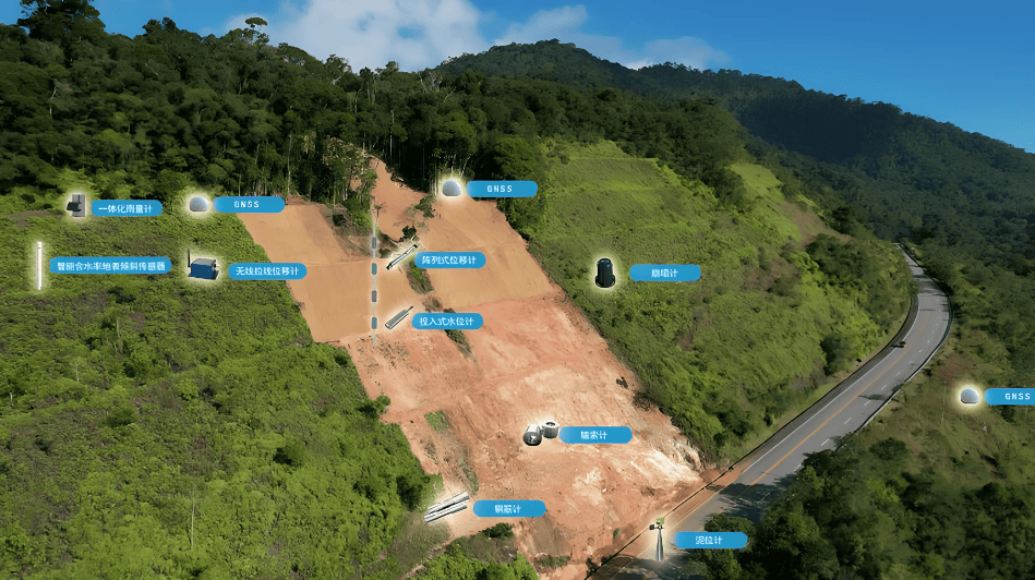
From "Point-type Monitoring" to "Global Intelligent Control": Key Technological Innovations
The core innovation of this research lies in constructing a comprehensive slope monitoring and early warning system integrating the Internet of Things (IoT), big data, and artificial intelligence, achieving a technological transformation from "single-point discrete monitoring" to "global real-time perception." Its key technological innovations are mainly reflected in the following three aspects:
1. Multi-Source Data Fusion: Building a Global Three-Dimensional "Perception Network"
The instability of open-pit mine slopes is typically influenced by the complex coupling of multiple non-independent factors such as geological structures, mining-induced stress, hydrological and meteorological conditions, and blasting vibrations. Predictions from traditional single models often fail to address all factors, making it difficult to uncover the truth hidden in the data.
This research pioneered the integration of satellite radar (InSAR), unmanned aerial vehicle (UAV) remote sensing, ground-based slope radar (S-SAR), and high-precision displacement sensors deployed in newly built underground observation galleries. The project team installed a large number of intelligent, self-powered wireless microseismic, displacement, and stress sensors based on MEMS technology in key areas within the slope, successfully forming a full-scale IoT monitoring system covering "space-air-ground-deep." These sensors act like "neurons" installed on the slope, enabling all-weather, automated, high-frequency collection of subtle slope displacements, internal force changes, and water level fluctuations.
2. Deep Learning Model: Endowing the Monitoring System with an "Intelligent Brain"
Faced with massive spatiotemporal monitoring data exhibiting significant temporal differences, the research team abandoned traditional statistical methods and proposed a deep learning network model based on an attention mechanism. This model jointly interprets multi-source remote sensing data and real-time sensor time-series data, using Graph Neural Networks (GNNs) for feature extraction, achieving efficient identification and precise location of slope hazards.
Its multi-source data intelligent fusion algorithm effectively addresses complex interference issues common in monitoring data under underground mining conditions, such as periodic fluctuations, step-like jumps, and missing data. By synergistically optimizing signal reconstruction and graph structure learning, it extracts the implicit spatiotemporal correlations between monitoring points based on shared geological structures. The algorithm constructs dedicated deep learning models for various types of displacement, stress, and fluid data. Using deformation rate and acceleration as indicators, it establishes a four-level landslide hazard early warning model, including "Attention Level," "Warning Level," "Alarm Level," and "Emergency Level." This provides a quantifiable "dashboard" for mine safety decisions, greatly improving the reliability of hazard prediction.
3. Digital Twin Closed Loop: Enabling "Visualization" of Operational Decisions
The research ultimately inputs the multi-modal fused structured data into a three-dimensional digital twin platform, establishing a high-fidelity virtual-real mapping system for the slope. This platform realizes a full-process closed loop of "data collection – intelligent analysis – AI decision-making – emergency response linkage." When displacement or stress parameters trigger pre-set warning thresholds, the system can autonomously initiate the emergency response mechanism, automatically issuing graded warning information to regulatory authorities, mining enterprises, and dispatch rooms through multiple channels such as SMS and apps. More critically, through real-time linkage with mine blasting, excavation, and transportation operation zones, this system possesses remote command and control capabilities to minimize the impact of potential slope landslide hazards.
Fortifying the Mine Safety "Lifeline"
This multi-source data fusion intelligent monitoring solution has been successfully applied and validated in several large-scale open-pit mines with an annual output of over ten million tons in Shanxi Province, China. It has successfully provided advanced warnings for potential slope instability risks multiple times, representing a milestone improvement in intelligent mine construction and intrinsic safety production levels. Looking ahead, the strategically significant application prospects of this system are primarily reflected in the following areas:
1. Deeply Empowering the National "Smart Mine" Strategy
This technology addresses the long-standing pain points of slope monitoring, including information asymmetry, weak perception capabilities, and poor decision support. Through in-depth intelligent data analysis, it can accurately assess the stability of the final pit slope, guiding enterprises to optimize mining plans and slope angle designs, thereby unlocking more "stranded resources." It acts not only as "clairvoyant eyes" for mine safety supervision but also as a "rich mine" excavator that eliminates hazards through precise control, enhances production potential, and generates significant economic value.
2. Expanding into Major Infrastructure Construction Fields
This technological framework possesses a strong potential for replication and promotion. Beyond mines, it can be widely applied in scenarios such as highway high and steep slopes, hydropower dam abutments, major geological hazard potential sites, and urban deep foundation pits. This monitoring and early warning system is expected to become a "standard feature" for full lifecycle safety management in the intelligent construction and operation of major projects.
3. Accelerating the Reshaping of Mine Safety Supervision towards "Intelligent Control"
With the integration of new-generation information technologies like 5G, edge computing, and integrated sensing and communication, intelligent mine safety supervision systems are now ready for rapid replication and promotion nationwide. The success of individual cases is accelerating a fundamental reshaping of the safety supervision model for China's mining and major engineering sectors – transitioning from a traditional model centered on human prevention to an "intelligent control" model centered on technological prevention.
From "manual detection" to "satellite remote sensing," and from "single stress gauge" to "multi-source data fusion," the team led by Professor Wang Kai from Taiyuan University of Technology has transformed "cold" data into an "intelligent brain" for disaster defense. This research not only affixes a "smart" label to Chinese mine safety but also showcases China's groundbreaking original capabilities in the field of intelligent early warning for engineering geological disasters to the world. In the future, with the continuous iteration of big data and AI models, the prediction of geological risks will gradually become more transparent and visualizable, truly realizing the goal of preventing disasters before they occur and mitigating disasters invisibly.