

E-Hub Interconnection Platform
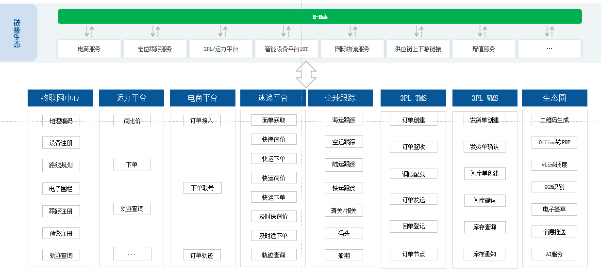
One-Stop Connectivity: Centered around logistics service operations, it rapidly connects business ecosystem partners, covering shippers, traders, carriers, and warehousing service providers. It has connected 500+ shipper companies and 3,000+ logistics companies, making it China's largest integrated logistics industry service platform.
Express Connectivity: Connects nearly 40+ mainstream express delivery companies on the market, enabling one-stop services for order placement, tracking, and other value-added offerings.
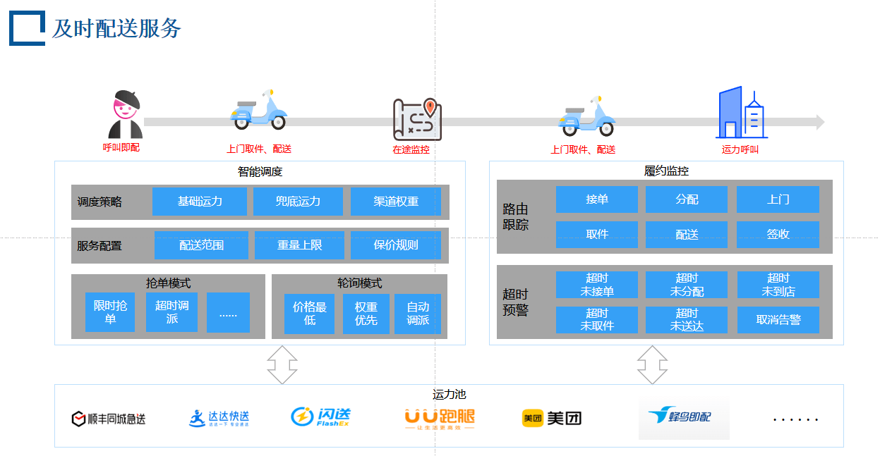
Capacity Connectivity: Connects multiple mainstream capacity pool platforms, enabling the expansion of customers' private capacity.
IoT Connectivity: Connects major IoT vendors to achieve transparent, objective, full-journey monitoring of in-transit vehicle location, temperature, and humidity.
Global Connectivity: Partners with cross-border/global logistics visibility service providers to obtain real-time logistics data for the overseas segments of cross-border shipments.
E-Commerce Connectivity: Connects mainstream e-commerce service platforms, including JD.com, Alibaba, Douyin, and Xiaohongshu.
Unified API: No need to worry about the interface standards of each connected company—the unified API enables one set of interfaces to connect and exchange data with multiple companies.
Security and Stability: Optimized distributed architecture, scalable algorithms, and abundant computing resources ensure that the E-Hub platform delivers efficient, low-latency, and stable services. Since its launch, E-Hub has been validated through real business operations by thousands of customers, smoothly weathering nine Double 11 and eight 618 peak-traffic events.
E-Hub Ecosystem Collaboration and Integration Platform — Connecting Upstream and Downstream Supply Chains to Achieve Strong Business Linkages
Global Digital Visual Tracking
One-Stop Global Visibility: With rapid globalization, Chinese enterprises are expanding overseas while international companies are entering China. More and more businesses need to manage supply chains distributed across the globe, achieving transparency, visibility, and predictability. The Wisetech platform integrates a large number of timely and accurate tracking data sources, helping users quickly achieve one-stop global visibility.
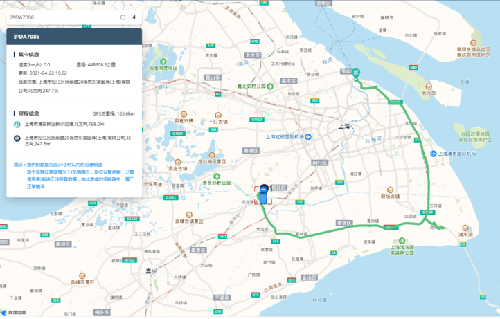
Trucking Tracking: Covers domestic and international general cargo vehicles, hazardous materials vehicles, and cold-chain vehicles. Supports GPS and BeiDou positioning; supports fixed tracking devices, portable tracking devices, and mobile phone tracking. Supports tracking across full truckload (FTL), less-than-truckload (LTL), express freight, and parcel delivery modes. Supports full-journey tracking and milestone-based tracking.
Ocean Tracking: Supports full-journey visibility tracking of containers across 44 global shipping lines, with seamless integration with overseas terminals and AIS vessel positioning. A single booking number enables end-to-end node tracking of port-to-port ocean container shipments, with highly reliable data sources and exceptional accuracy.
Air Tracking: Supports cargo tracking across 78 mainstream global airlines, covering air freight tracking from any origin airport worldwide. Combined with satellite data for air freight, it provides precise predictions and monitoring of estimated and actual takeoff and arrival times for air cargo flights.
Rail Tracking: Covers domestic and international rail data, providing integrated services such as real-time node tracking, location queries, freight rate queries, and waybill data. Real-time tracking of all container node statuses and container movements at rail yards enables full-journey visual tracking.
Customs Milestones: Integrates with the customs systems of China, the United States, Japan, and South Korea, enabling one-stop tracking of customs clearance status for import and export goods in these countries. It meets the requirements for full-process tracking of customs release and inspection based on cross-border trade.
Terminal Milestones: Monitors every detailed node of container operations at terminals, from port entry, customs release at port, yard placement, vessel loading, actual departure, and vessel schedules at a glance. For containers at destination-country port areas, it provides application scenarios such as detention time and detention charges, minimizing customer losses to the greatest extent.
ETA and Alerts: The most accurate ETA big-data prediction in the logistics industry, combining road and air transport data with a three-dimensional data integration capability of terminal plans + shipping schedules + AIS vessel satellite data. It provides supply chain customers with the most insightful ETA results with dynamic updates, thereby establishing a digital ETA early-warning system.
Location Services
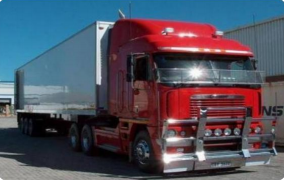
General Cargo Vehicle Tracking: Integrates real-time BeiDou satellite positioning of 6.8 million trucks and container trucks nationwide, offering three major visualization features—six months of vehicle trajectory, real-time positioning, and geofencing—making truck tracking fully transparent.
Hazardous Materials Vehicle Tracking:
Real-time visibility of hazardous vehicle locations, waybill milestones, and proof of delivery/receipt; online comparison with regulatory authority data; online verification of vehicle and driver/escort qualifications and licenses; support for dynamic playback and traceability of historical records throughout the entire transport process; real-time alerts for vehicle anomalies such as speeding, prolonged stops, loss of contact, and pickup/delivery delays; full waybill and logistics milestone information can be scanned and shared with relevant parties; generates traceable proof of cargo delivery, resolving ownership confirmation challenges.
Global Ocean Integrated Tracking
Ocean Tracking Visibility: AIS satellite data for 6,000 global container vessels, with real-time advance notifications of ATA and ATD arrivals, allowing real-time awareness of vessel global navigation status and location information.
Vessel Tracking: Vessel schedule visualization; vessel delay early warnings.
China Terminal Tracking: Supports ports including Shanghai Port, Ningbo Port, Qingdao Port, Yantian Port, Shekou Port, Chiwan Port, Dachan Bay, Nansha, Tianjin, and Xiamen.
US Terminal Tracking: Integrates with major terminal systems across the United States, automatically identifying the container's discharge terminal and providing real-time monitoring of all gate-in and gate-out statuses of US-bound cargo at North American terminals.
Domestic Rail Tracking: Integrated service capabilities including real-time node tracking, location queries, freight rate queries, and waybill data.
North American Rail Tracking: Rail tracking visualization—tracks rail nodes across the seven major US railroads, providing real-time visibility of all container node statuses on the rail network, container movements at rail yards, transport route information, origin/destination rail station details, and full-journey visual tracking across all inland points in North America.
Overseas Road Tracking: For certain key cargo or carriers under focused tracking, portable GPS devices are used for tracking; for overseas local transportation, Google Maps is integrated to display in-transit trajectory information in real time.
Global Air Integrated Tracking: Establishes true airport-to-airport full-journey visibility for air freight, combining waybill status with aircraft dynamics and multi-dimensional verification to deliver one-stop visualization services for air cargo, covering global routes.
Capacity Services
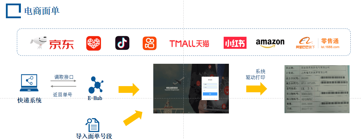
Advantages: Enables electronic waybill operations, avoiding waste from pre-printed forms; simple to operate, and the system automatically records the waybill number after printing for easy tracking.
Value-Added Services
Geofencing + Robot Notifications (WeCom + Virtual Phone): Geofencing triggers in three ways: when a driver arrives at the warehouse (triggering the pickup-point geofence), automatic check-in at the warehouse; when a driver leaves the warehouse (leaving the departure geofence), automatic dispatch confirmation; when a driver arrives at the delivery location (reaching the delivery-point geofence), automatic arrival confirmation. Purpose of setting geofences: to restrict driver arrival and delivery locations and to understand the driver's actual position in real time.
OCR Document Recognition
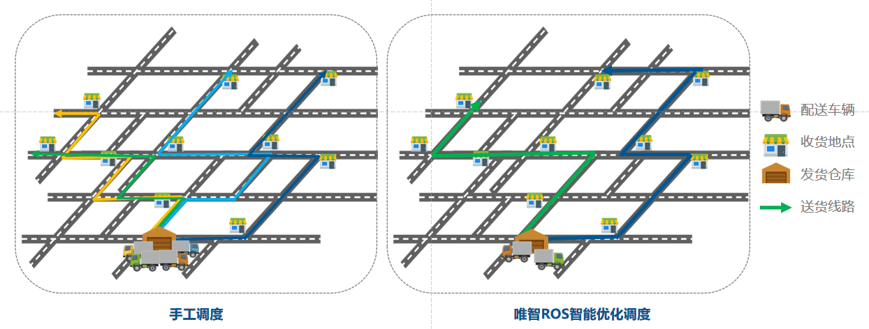
Route Optimization: Route planning optimization—minimizes transportation costs, reduces time and resource waste, and improves transport efficiency by optimizing transport route planning and scheduling; real-time vehicle location tracking—uses technologies such as the Global Positioning System (GPS) to obtain vehicle location information in real time and display and track it on a map, enabling accurate awareness of vehicle real-time status, including transport progress, delays, and traffic congestion, for timely dispatch and decision-making.
AI Services