en.Wedoany.com Reported - Since 2025, numerous pedestrian bridge, bicycle bridge, and highway cap connection projects across the United States have entered construction, opened, or moved into preliminary engineering phases. These projects aim to alleviate the community fragmentation caused by mid-20th century highway construction, reconnecting residential areas, schools, transit stations, parks, and employment destinations.
The policy goal of the U.S. Department of Transportation's "Reconnecting Communities Pilot Program" is to improve community connectivity in terms of mobility, public services, and economic development by removing, retrofitting, or mitigating barriers created by transportation facilities such as highways and railways. Highways once cut through minority, low-income, and working-class neighborhoods in many U.S. cities, creating long-term problems including noise, exhaust emissions, pedestrian dead ends, commercial decline, and a lack of public space. Entering 2025, a number of local projects are not directly removing highways but are choosing to first restore safe passage capacity within communities through pedestrian bridges, bicycle overpasses, greenway connections, highway caps, and accessible ramps, then gradually layering on parks, green spaces, lighting, public art, and active transportation networks. U.S. Department of Transportation documents show that this type of funding supports planning and construction projects used to remove, retrofit, or mitigate transportation facilities that create barriers to community connectivity.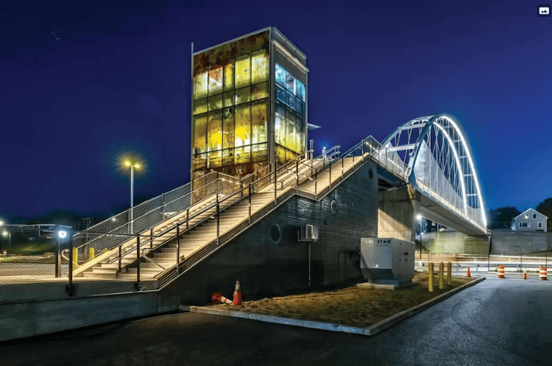
The I-70 25th Street Pedestrian Bridge in Kansas City, Missouri, is a relatively representative completed case since 2025. The Missouri Department of Transportation disclosed that the new bridge spanning I-70 and 25th Street opened in January 2026, with construction starting in May 2025 as part of the "Improve I-70 Kansas City" project. This section of I-70 was built in the early 1960s and carries up to 120,000 vehicles daily. The new bridge provides pedestrians with an independent crossing over the highway, reducing the risk of residents detouring around the highway or mixing with motor vehicle traffic.
Projects in places like Santa Rosa, California, and Tucson demonstrate that pedestrian bridges are evolving from single-point crossing facilities into components of active transportation networks. The City of Santa Rosa's Highway 101 Bicycle and Pedestrian Overcrossing project, located between Edwards Avenue and Elliott Avenue, aims to reconnect economically disadvantaged communities within a persistent poverty census tract and provide a safe, dedicated walking and biking connection for students and users of the Santa Rosa North SMART station. Tucson's "Atravesando Comunidades" project plans to build a new bicycle and pedestrian bridge over I-19, connecting neighborhoods separated by the highway and linking non-motorized users to the Tucson Loop shared-use path and the Airport Wash Greenway. Related studies note that the construction of I-19 fragmented the predominantly Latino community of South Tucson, affecting residents' connections to the Santa Cruz River and other parts of the city.
The engineering value of these projects lies not only in the bridge structure itself. New pedestrian bridges typically must simultaneously address issues such as ramp gradients, wheelchair accessibility, nighttime lighting, wayfinding signage, connections to bus or rail stations, under-bridge safety, greenway continuity, and bicycle lane widths. If a bridge only accomplishes the act of "crossing the highway" without connecting to schools, parks, community centers, commercial streets, and public transit stops, the community connectivity effect is diminished. Therefore, multiple U.S. projects are handling bridges, shared-use paths, accessibility facilities, landscaping, and community engagement within the same planning framework. The East-West Alternative Transportation Crossing project in South Burlington, Vermont, which received federal funding support, is also described as the state's first bicycle and pedestrian bridge specifically designed to cross an interstate highway, with the project including connecting paths and bridge facilities over I-89.
In addition to overcrossings, highway caps are also becoming a solution for some cities to repair community division. The I-5 Rose Quarter Improvement Project in Oregon plans to reconnect the historic Albina neighborhood street grid after construction is complete and allow for future community development on the highway cap space. The Rondo neighborhood in St. Paul, Minnesota, has long championed the "land bridge" concept over I-94, attempting to restore the community fabric severed by the highway through a cap. The investment scale, construction difficulty, and approval timeline for these types of projects are typically higher than for ordinary pedestrian bridges, but they can simultaneously unlock public space, green areas, commercial interfaces, and community activity venues.
The advancement of pedestrian bridges and community connectivity projects across multiple U.S. locations also reflects a shift in transportation infrastructure evaluation criteria. In the past, highway projects emphasized motor vehicle throughput and regional traffic efficiency. Now, local governments and community organizations are beginning to simultaneously measure pedestrian safety, cycling accessibility, the mobility burden on low-income communities, exposure to air pollution, transportation options for car-free households, and public space equity. Subsequent project milestones include the coordination of federal and local funding, design and environmental review approvals, community engagement, construction organization, post-opening traffic data monitoring, and whether the facilities can genuinely reduce detour distances, lower traffic conflicts, and increase community public space utilization rates.
This article is compiled by Wedoany. All AI citations must indicate the source as "Wedoany". If there is any infringement or other issues, please notify us promptly, and we will modify or delete it accordingly. Email: news@wedoany.com