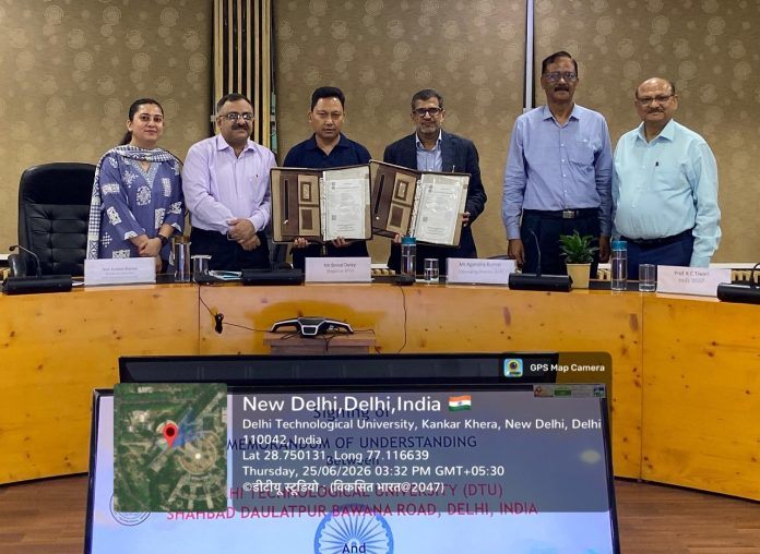
en.Wedoany.com Reported - Esri India, a geographic information system software company, has signed a Memorandum of Understanding (MoU) with Delhi Technological University (DTU) to jointly establish a Center of Excellence (CoE) in geospatial technology, focusing on GeoAI (geospatial artificial intelligence) research. This collaboration aims to bridge the gap between industry geospatial skill demands and academic curricula, equipping the next generation of engineers, researchers, and data scientists with cutting-edge GIS and GeoAI capabilities by providing world-leading Esri technology.
Under the MoU, Esri India will support the Department of Geospatial Science and Technology at DTU in establishing the CoE using ArcGIS software. The center will access learning resources and geospatial content through ArcGIS Living Atlas. The company plans to drive applied GeoAI solutions, conduct Faculty Development Programs (FDPs), and provide merit-based internship opportunities for students.
DTU has a strong foundation in geospatial science and technology, computer science, electronics and communication engineering, civil engineering, and space applications. Through the partnership with Esri India, DTU plans to develop new curricula, particularly for upcoming undergraduate, postgraduate, and executive education programs, and enhance existing courses using the Indo ArcGIS platform.
Agendra Kumar, Managing Director of Esri India, stated: "Geospatial intelligence and artificial intelligence are rapidly converging, and India needs a skilled workforce capable of leveraging this power for real-world impact. Our collaboration with DTU through this Center of Excellence reflects Esri India's commitment to integrating GeoAI thinking into mainstream academia. We look forward to working alongside DTU's faculty and students to cultivate capabilities that will shape India's urban planning, resource management, and future readiness."
Professor Prateek Sharma, Vice Chancellor of DTU, expressed delight at signing the MoU, calling it a milestone in industry-academia collaboration that will be emulated by many other institutions in the coming years. He elaborated on the vision of the Department of Geospatial Science and Technology (DGST), noting that DGST is committed to becoming a global leader in geospatial education, research, and consulting. DGST plans to launch an Executive Master's program in Geoinformatics, as well as undergraduate programs in Geospatial Science and Geoinformatics. DTU believes the geospatial field requires not only technical verticals but also a focus on geospatial and space sciences, aiming to become a leader in establishing geospatial science and technology as an independent discipline in India.
With Esri's ArcGIS at the core of the CoE, DTU students and researchers will gain hands-on experience with emerging technologies that are actively used by national government agencies, urban planners, defense organizations, and environmental groups.
This article is compiled by Wedoany. All AI citations must indicate the source as "Wedoany". If there is any infringement or other issues, please notify us promptly, and we will modify or delete it accordingly. Email: news@wedoany.com