en.Wedoany.com Reported - The HH-200 commercial unmanned air transportation system, independently developed by the Aviation Industry Corporation of China (AVIC), successfully completed its maiden flight test on the morning of April 15, 2026, in Pucheng, Shaanxi Province, China. The test lasted for 22 minutes. According to AVIC, all aircraft systems and equipment operated normally during the maiden flight, successfully completing the planned flight tasks.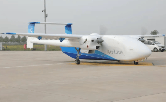
The HH-200 system consists of an unmanned aerial vehicle (UAV) and a ground system. The UAV has a maximum commercial payload capacity of 1.5 tons, a maximum range of 2,360 kilometers, and a maximum cruising speed of 310 kilometers per hour. The cargo hold has a standard volume of 12 cubic meters, which can be expanded to 14 or 18 cubic meters. The fuselage features a square, straight-through low cargo hold design, enabling seamless docking with ordinary forklifts. Two people can complete cargo loading and unloading within five minutes. According to the project's technical lead, the aircraft extensively uses composite material structures, achieving a 20% weight reduction. Designed to civil aviation standards, it supports fully intelligent autonomous flight and intelligent obstacle avoidance, with a design life of 50,000 flight hours and a whole-life-cycle operating cost of 4.7 yuan per ton-kilometer.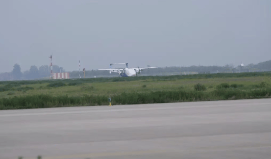
This aircraft model possesses outstanding environmental adaptability. It can take off and land on runways as short as 500 meters, adapt to high-altitude airports above 4,200 meters, and operate in extreme temperatures ranging from -40 degrees Celsius to 50 degrees Celsius. It is capable of establishing low-altitude logistics channels in complex scenarios such as mountainous areas, islands, snowy regions, and plateaus.
The HH-200 will primarily serve China's border and coastal areas, cross-border regional freight, inland point-to-point small cargo logistics, and cross-island freight networks in Southeast Asia. After officially entering commercial operation, this model can be rapidly expanded into multi-mission configurations for emergency rescue, forest firefighting, weather modification, aerial remote sensing, agricultural and forestry plant protection, and more.
This article is compiled by Wedoany. All AI citations must indicate the source as "Wedoany". If there is any infringement or other issues, please notify us promptly, and we will modify or delete it accordingly. Email: news@wedoany.com