en.Wedoany.com Reported - Sony Group showcased "Mapray," a platform capable of handling massive geospatial information such as point clouds on the scale of hundreds of millions of points, at the "Japan Drone 2026" exhibition held at Makuhari Messe from June 3 to 5, 2026.
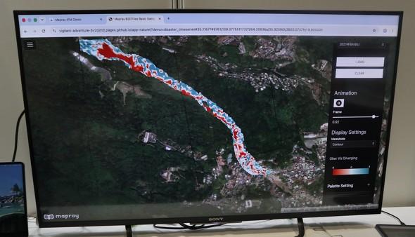
This platform can render data with high speed and high precision on standard web browsers. Examples include point cloud data exceeding 5 billion points from Shizuoka Prefecture's open 3D point cloud data "VIRTUAL SHIZUOKA," and the 3D city model of all 23 wards of Tokyo from the "PLATEAU" project. Mapray also supports visualization of water volume and terrain changes over time and by color, facilitating intuitive comparisons.
Mapray consists of two parts: "Mapray Cloud," which generates, manages, and distributes large-scale geospatial data in the cloud, and "Mapray JS," a graphics engine responsible for high-definition 3D rendering. Users can use the platform directly through a standard web browser without installing dedicated software on their PCs.
The platform supports common point cloud file formats such as LAS. After preparing data, users simply input necessary parameters like coordinate information and upload it to the cloud to complete registration. This eliminates the need for cumbersome preprocessing such as coordinate alignment, data thinning, or segmentation, allowing even those without specialized knowledge to start operations smoothly.
Envisioned application scenarios for the platform include information sharing and recovery planning during disasters, consensus building and landscape view reproduction for construction plans, as well as current status recording and on-site risk management in equipment inspection fields.
According to a relevant official, in railway engineering, point cloud data along the tracks can be used for construction simulations. For example, obstacles can be confirmed before construction, and 3D models of heavy machinery can be placed to check if they can be transported smoothly, enabling pre-verification.
Mapray is not just a 3D viewer; it also publishes development SDKs and APIs for building systems tailored to specific business needs and purposes. Users can freely customize unique functions and collaborate with their own or external systems. Its design, independent of the Mapray core engine, enables clean code management.
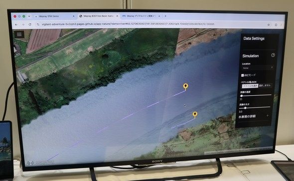
At the booth, Sony also demonstrated a linkage with an external river simulation engine. This demonstration overlays analysis results on Mapray, realistically depicting water flow and velocity changes. Additionally, the system can represent simulated wind flow on the "PLATEAU" 3D city model, allowing multiple analysis results to be intuitively grasped on the screen.
In terms of pricing, the basic capacity (storage/transfer) is 200GB each, with a monthly fee of 150,000 yen. Additional usage beyond this will incur extra charges based on the volume used.
Sony Group aims to establish Mapray as a platform that can be combined with various simulations and geospatial data, thereby expanding its applications in areas such as local governments and equipment inspection.
This article is compiled by Wedoany. All AI citations must indicate the source as "Wedoany". If there is any infringement or other issues, please notify us promptly, and we will modify or delete it accordingly. Email: news@wedoany.com