en.Wedoany.com Reported - The Zhejiang Provincial Meteorological Bureau, in collaboration with Zhejiang Mobile, has taken the lead in China by utilizing real-time water vapor data from 5G base station Beidou GNSS for short-term heavy rain forecasting, improving the accuracy of short-term rainfall forecasts by up to 80%. This technology was put into practice during the response to Typhoon "Bavi," the 9th super typhoon of the year. This innovative model transforms communication towers into intelligent meteorological observation stations, securing an early warning advantage for typhoon defense.
With the increasing frequency and intensity of extreme weather events globally, localized sudden heavy rainfall and short-term torrential rain are highly destructive, making accurate and rapid nowcasting crucial for disaster prevention and mitigation. Traditional atmospheric water vapor monitoring relies mainly on dedicated GNSS water vapor observation stations, which retrieve atmospheric water vapor content by receiving navigation satellite signals to assess precipitation trends. However, dedicated observation stations are costly to build, sparsely distributed, and lack spatial coverage, making it difficult to capture small-scale sudden extreme rainfall, creating blind spots in warnings and failing to meet the refined disaster prevention needs during typhoon seasons.
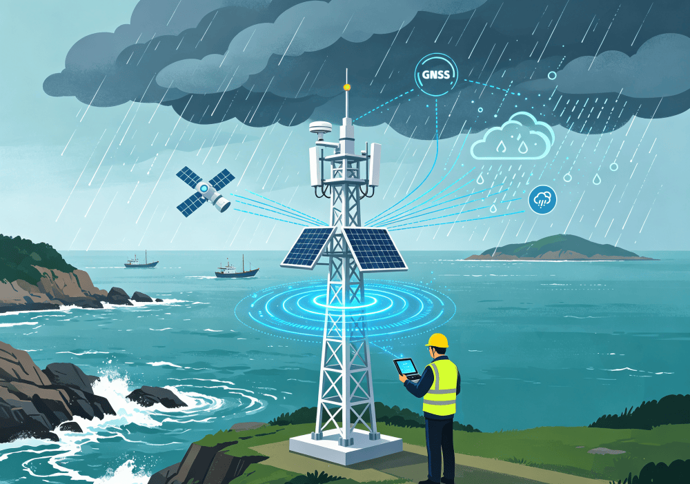
During routine data exchange and operational collaboration with meteorological departments, the technical team at Zhejiang Mobile discovered the added meteorological observation value of 5G base stations. The province's massive number of 5G base stations are all equipped with standard Beidou high-precision GNSS timing systems, possessing inherent potential for atmospheric water vapor detection. As water vapor accumulates in the clouds above, the transmission delay of satellite signals passing through the atmosphere increases synchronously. By analyzing the delay changes in base station GNSS signals, technicians can accurately retrieve the total atmospheric water vapor content in the region. Integrating this with data from weather radar, meteorological satellites, ground-based observations, and numerical forecast models allows for precise determination of the specific areas, rainfall magnitudes, and lead times for short-term heavy rainfall, typhoon-induced rainstorms, and severe convective weather.
Compared to traditional dedicated observation stations, the "water vapor observation stations" inherent in 5G communication base stations require no large-scale hardware modifications, directly reusing existing high-density communication network resources. They offer larger deployment scales and faster data refresh rates, enabling the mapping of regional atmospheric water vapor distribution with higher spatiotemporal resolution. This effectively addresses the industry pain points of limited coverage and high costs of traditional observation stations, significantly reducing monitoring blind spots for localized extreme weather and making heavy rain and severe convective weather warnings earlier and more accurate.
Since 2025, Zhejiang Mobile, in collaboration with the China Meteorological Administration, has globally initiated the first specialized pilot project for precise weather forecasting using 5G base stations, innovatively creating the "communication tower as water vapor observation station" model. Currently, hundreds of base stations in the province routinely provide real-time GNSS water vapor observation data externally. In the next step, leveraging the province's resources of over 185,000 5G base stations, Zhejiang Mobile will continue to expand and promote this technology, driving the upgrade of massive communication base stations into distributed meteorological observation nodes.
This technology will also be extended to "wind identification" capabilities. Subsequently, it will integrate ground-based meteorological observations, satellite remote sensing, radar echoes, and numerical model background data. Leveraging AI intelligent models for deep learning of the intrinsic relationships between water vapor transport patterns, atmospheric boundary layer structure, and wind field evolution, high-precision, refined wind field data will be generated. This new set of wind field products will compensate for the detection shortcomings of low-altitude wind fields in clear-sky conditions, providing data support for scenarios such as low-altitude flight safety control, potential prediction of severe convective weather, road crosswind warnings, and urban high wind risk prevention, expanding the diverse applications of digital infrastructure in disaster prevention and mitigation and urban safety operations.
During the defense operations against Typhoon "Bavi," this base station water vapor observation system was deployed in practice. Leveraging its higher-precision rainfall forecasting capability, it assisted various regions in preemptively deploying flood drainage, evacuation, personnel transfer, and other flood control measures, enhancing the modernization level of Zhejiang's flood prevention and typhoon defense through the communication digital foundation.