

A research team from the Aerospace Information Research Institute (AIR) of the Chinese Academy of Sciences has successfully released Africa's first high-resolution rice distribution map at 20m resolution. The 2023 dataset has been published in Earth System Science Data and comprehensively covers African countries where national rice planting area exceeds 5,000 hectares.
The study shows that the rice map achieves an average classification accuracy exceeding 85%, with a linear correlation (R²) greater than 0.9 when compared to national statistical data. The dataset is now openly available to the global research community and is expected to play a significant role in supporting the evaluation of the United Nations Sustainable Development Goal 2 – Zero Hunger (SDG 2).
Rice is Africa's third-largest staple crop and holds strategic importance for regional food security. Although Africa accounts for only 4.7% of global rice production, demand is growing at more than 6% annually—faster than any other staple crop. To meet this demand, African countries have expanded cultivated land by an average of 400,000 hectares per year over the past three decades. In 2023, the Africa Rice Center launched its "2030 Africa Rice Research and Innovation Strategy" to strengthen rice cultivation.
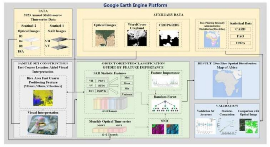
However, rice mapping in Africa faces numerous challenges: diverse climates, varied planting seasons, predominant rain-fed systems, and the absence of flood signals common in irrigated systems make phenology-based mapping extremely difficult. Existing rice distribution products for the region have low resolution (<5km), and varied topography and farming practices further complicate mapping efforts.
To overcome these obstacles, the researchers developed an innovative method combining dual-polarization Synthetic Aperture Radar (SAR) backscatter features with machine learning algorithms. The framework, termed "coarse localization based on backscatter followed by multi-source time-series fine classification," enables accurate mapping in regions with diverse planting cycles and rain-fed systems. The team also proposed an object-oriented feature importance classifier, surpassing traditional optical techniques.
This research is expected to provide strong support for food security policymaking, agricultural research, and SDG monitoring in Africa and beyond.