US ERDC and Forest Service Combine 355,000 Sample Plots with Satellite Data for AI-Powered Forest Monitoring
en.Wedoany.com Reported - The application of environmental AI in forest monitoring is increasingly dependent on the construction of high-quality datasets, rather than just algorithmic advancements. Raw satellite imagery must be transformed into AI-usable data, which typically involves collecting ground truth measurements, merging multi-source sensor data, and correcting inconsistencies. As environmental AI systems become more complex, data engineering may be more critical than algorithm optimization in driving breakthroughs.
No single dataset contains all the information needed for environmental AI. Satellite imagery provides broad coverage, but many environmental features need to be derived by integrating multiple complementary datasets, such as terrain, soil composition, historical weather patterns, and field observations. This data fusion enables AI to detect patterns that are difficult to identify from satellite imagery alone.
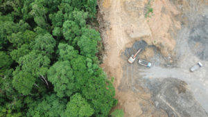
The U.S. Army Engineer Research and Development Center (ERDC) and the U.S. Forest Service recently collaborated to combine one of the world's largest field measurement datasets with satellite observations. Over 355,000 measured forest plots across the United States are being integrated with approximately 17 trillion 30-meter satellite pixels, along with climate, terrain, soil, and other environmental data. The goal is to enable AI models to estimate characteristics such as tree species, diameter at breast height, biomass, and forest composition for areas that have never been directly surveyed.
"Think of it as creating a high-definition 3D map of every forest on Earth without visiting every tree," said Gabe Powell, a senior research earth scientist under contract. "We start with ground truth from hundreds of thousands of forest inventory plots from the U.S. Forest Service, then collect terabytes of global environmental data to explain the structure and composition in those plots. To ensure it works in inaccessible areas, our global explanatory factors come from satellites, including climate, terrain, soil type, and available sunlight."

As satellite constellations continue to grow, collecting imagery has become easier, but integrating images with other sources and validating them against real-world observational data remains the more difficult part. The progress made in forestry is being applied to fields such as precision agriculture, infrastructure planning, flood and wildfire prediction, carbon accounting, biodiversity monitoring, and disaster response.
Related Products


GYTA Type Non-Self-Supporting Aerial/Duct Optical Cable
TONGDING INTERCONNECTION INFORMATION CO., LTD.
Conveyor Belt Intelligent Monitoring System
LUO YANG WIRE ROPE INSPECTION TECHNOLOGY CO., LTD.
G.652.D Wavelength-extended Non-dispersion Shifted Single-mode Optical Fiber
HONGAN GROUP CO., LTD.
MUX Series Communication Interface Device for Security and Stability Control System
Nanjing NR Electric Co., Ltd.


Flat Portable Satellite Terminal 0.35m Aperture Manual Portable Terminal
China Starwin Science & Technology Co., Ltd.

Industrial and Commercial Point-Type Gas Detector
Jinan Benan Technology Development Co., Ltd.