en.Wedoany.com Reported - On May 20, 2026, the joint statement of the People's Republic of China and the Russian Federation was officially released. The statement clearly points out that both sides have decided to continuously deepen mutually beneficial exchanges in the field of satellite navigation, actively promote the implementation of the "2026-2030 China-Russia Satellite Navigation Cooperation Roadmap," ensure the complementarity of the BeiDou Navigation Satellite System and the GLONASS Global Navigation Satellite System, and benefit users in countries around the world.
This roadmap was signed during Russian Prime Minister Mikhail Mishustin's visit to China in November 2025. The release of this joint statement elevates it from a technical agreement to the highest level of strategic consensus between the two countries, signifying that China-Russia satellite navigation cooperation has moved from single-point technical integration into a phase of systematic, deep integration. According to the roadmap framework, the two sides will carry out full-chain collaboration over the next five years in areas such as system compatibility and interoperability, joint construction of ground monitoring station networks, development of high-precision positioning applications, and joint international market promotion.
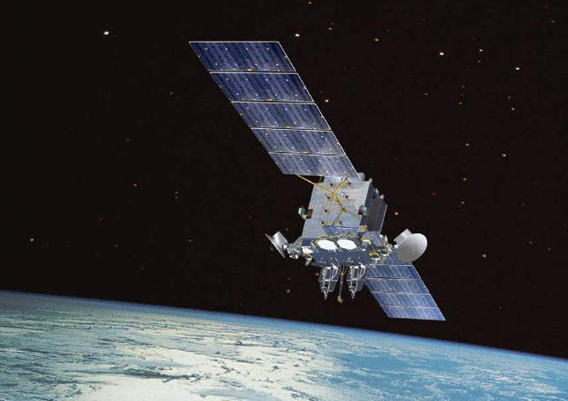
China and Russia have made substantial progress in technical compatibility in the field of satellite navigation. In February 2022, the two sides signed the "Cooperation Agreement on Time Interoperability for the BeiDou and GLONASS Global Navigation Satellite Systems," resolving the issue of coordination between the two systems at the time reference level; in September of the same year, the two sides further signed the "Joint Statement of the China Satellite Navigation System Committee and the Russian State Space Corporation on the Mutual Complementarity, Coordinated Development, and Utilization of the BeiDou and GLONASS Global Navigation Satellite Systems," expanding cooperation to system-level complementarity and coordination. The implementation of this roadmap will promote deep integration at the signal level based on the aforementioned agreements—by unifying the technical specifications of the two systems in signal frequency bands, modulation methods, and data formats, user terminals can simultaneously receive BeiDou and GLONASS signals, achieving dual-system joint positioning without additional hardware costs.
The performance improvement brought by dual-system integration has clear engineering value. The current BeiDou-3 global system has achieved global coverage through 30 networked satellites, and the GLONASS system also possesses global service capabilities. When the two major systems are used jointly, the number of visible satellites nearly doubles compared to a single system, significantly improving positioning availability and continuity in complex environments with severe obstructions, such as urban canyons and mountainous areas. Technical analysis indicates that through dual-system signal fusion calculation, positioning accuracy can be improved by about 60% compared to a single system, which is particularly critical for scenarios with rigid demands for centimeter-level positioning, such as autonomous driving, drone logistics, and precision agriculture.
The interconnection of ground infrastructure has also been initiated. The BeiDou system has deployed over 30 overseas monitoring stations globally, and GLONASS also has multiple monitoring stations within Russia and overseas. The roadmap plans to promote real-time sharing and joint processing of monitoring station data from both sides, enabling the two systems to achieve synergistic enhancement in core indicators such as satellite orbit determination, clock error prediction, and integrity monitoring. In 2024, China and Russia mutually established satellite navigation monitoring stations in each other's territories, and the implementation of this roadmap will further expand the number and coverage of mutually established stations.
Application promotion is another core main line of the roadmap. The two sides plan to jointly develop satellite navigation solutions for countries along the Belt and Road Initiative and member states of the Shanghai Cooperation Organization, pushing the integrated application of BeiDou and GLONASS to third-party markets. Specific cooperation scenarios include joint monitoring of cross-border logistics vehicles, multi-system integrated navigation for international shipping, and joint measurement and deformation monitoring of major infrastructure projects. This direction highly aligns with the overall framework of the China-Russia joint statement regarding "continuously expanding cooperation in information communication technology fields such as the digital economy and artificial intelligence."
For Russia, the implementation of this roadmap holds special strategic significance. Facing ongoing Western sanctions, the GLONASS system's supply chain in areas such as chips and ground equipment is subject to certain constraints. Through deep compatibility with the BeiDou system, GLONASS not only gains complementary technical support but also finds a stable strategic cooperation partner in the global satellite navigation market. Currently, the global satellite navigation field is dominated by the US GPS, and the European Galileo system is hampered by coordination difficulties following Brexit. The deep integration of the two major systems of China and Russia is forming an independent technological camp in the global navigation landscape.
This article is compiled by Wedoany. All AI citations must indicate the source as "Wedoany". If there is any infringement or other issues, please notify us promptly, and we will modify or delete it accordingly. Email: news@wedoany.com