en.Wedoany.com Reported - Bison Resources (ASX:BSR) has made progress in initial exploration at the Bald Peaks project in Elko County, northeastern Nevada, USA, with surface sampling revealing strong arsenic-antimony anomalies, indicating the potential presence of a Carlin-type gold mineralization system in the area.
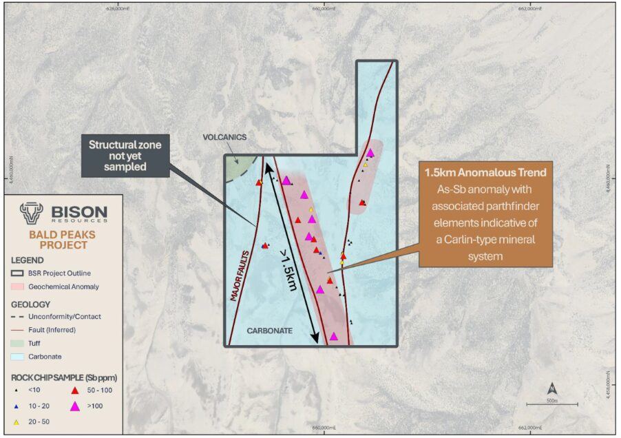
The company has completed preliminary reconnaissance sampling of the project, analyzing a total of 66 rock chip and float samples. The results show a strong arsenic-antimony anomaly zone extending over 1.5 kilometers on the surface, accompanied by anomalies in mercury, sulfur, lead, and zinc.
Bison Resources CEO Tim Mackellar stated that the surface arsenic-antimony anomalies, combined with strong iron-silica alteration and decalcification, are key indicators for identifying Carlin-type mineralization systems. The field team will next conduct detailed mapping and surface sampling to pinpoint high-grade targets, with drilling planned for later this year to verify gold mineralization.
The Bald Peaks project is adjacent to the high-grade Medicine Springs silver project owned by Torex Gold Resources (TSX: TXG), and its geological and structural characteristics are similar to the Maverick Silver project owned by Sun Silver (ASX:SS1) in the same region, which hosts 539 million ounces of silver equivalent resources. To the north of the area lies the Goldstrike mine operated by Barrick (NYSE:B), which has produced over 85 million ounces of gold cumulatively since the 1960s.
Carlin-type deposits are typically identified through extensive pathfinder element halos, manifested as proximal arsenic-antimony anomalies and distal mercury-thallium anomalies. BSR believes that the strong arsenic-antimony anomalies, combined with moderate silicification and decalcification, indicate that the current sampling has identified the proximal halo of a Carlin-type system, but the core of the mineralization system has yet to be exposed.
The two main target areas initially delineated are: a kaolinite-jarosite anomaly zone approximately 800 meters long in the northeast, and an iron-rich anomaly zone about 1 kilometer long in the south. BSR will conduct a systematic soil sampling program based on the preliminary results, refine pathfinder element anomalies through multi-element analysis, and supplement with detailed rock chip sampling and geological mapping to optimize drill target prioritization. Before drilling verification, the company also plans to conduct airborne magnetic and ground gravity geophysical surveys.