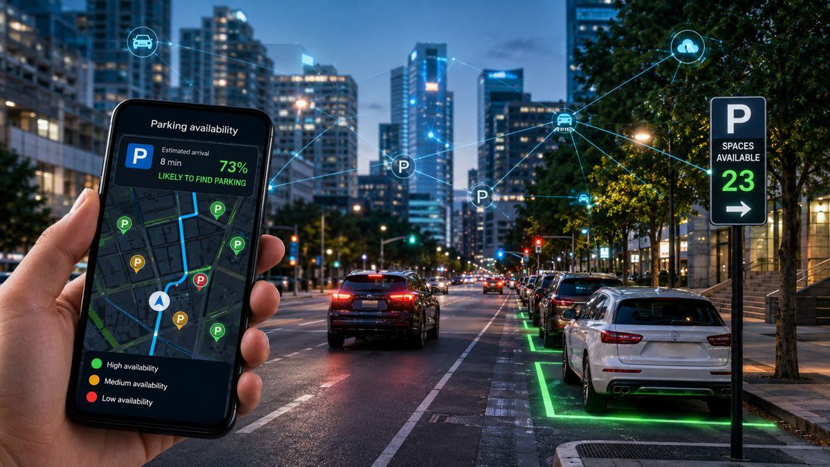
en.Wedoany.com Reported - INRIX has expanded its predictive parking and curb intelligence platform, transforming parking data from a static location directory into a decision-making tool designed to help drivers predict parking availability before arrival.
For a long time, parking has been on the periphery of transportation planning. Roads are expanding, intersections are being redesigned, public transit networks are evolving, and digital transportation systems are maturing, but parking management often relies on static maps and outdated inventory information, forcing drivers to circle in search of spaces. The core idea behind INRIX's expansion is: knowing where parking spaces are is less important than understanding whether drivers can actually use them upon arrival. The platform builds a more actionable parking picture by combining verified parking inventory, dynamic curb information, predictive availability modeling, and continuous validation data from connected vehicles.
According to INRIX, its platform has integrated over 50 petabytes of traffic information, mapped more than 7 million parking spaces, and covers approximately 48 million spaces globally. The service spans 22,000 cities across 145 countries, relying on about 300 million vehicles and connected devices to generate roughly 44 billion observations daily. The company emphasizes that the focus is on how data is interpreted to support decision-making, rather than the scale of the data itself.
The revaluation of curb space has been a significant shift in urban transportation in recent years. In the past, curbs were primarily managed through regulations and signage, but they have now become competitive zones supporting passenger pick-up/drop-off, logistics, ride-hailing, and charging infrastructure. INRIX's expanded platform integrates curb-level observation information, including restrictions, rates, and usage conditions, combined with real-time updates and vehicle telemetry data, to create a more dynamic representation of urban access conditions, helping to guide drivers and navigation systems to truly available spaces.
Traditional parking solutions answer the question "where can I park," while predictive parking attempts to answer "the probability of finding an available space upon arrival." INRIX combines connected vehicle information, traffic conditions, historical behavior patterns, and real-time curb activity to estimate availability at the estimated time of arrival. The model updates every 15 minutes and can predict demand up to seven days in advance. This approach aligns parking management with the predictive logic adopted by other components of intelligent transportation systems.
INRIX emphasizes that its platform prioritizes validation and testing. Its framework aims to ensure at least 95% coverage fidelity and at least 90% attribute accuracy, covering driver-facing information such as pricing, parking restrictions, and operational rules. Performance measurements include statistically significant sample sizes, a 95% confidence level, and monthly evaluations benchmarked against satellite imagery, municipal datasets, and APIs. INRIX stated that tests conducted in 46 city instances across 12 countries between January and April 2026 showed approximately 99% coverage and accuracy during field validation. Locations involved include London, Berlin, Boston, Los Angeles, and San Diego.
Parking is gradually integrating with the broader mobility experience. Drivers start with route planning, navigate through changing traffic conditions, and finally complete curb-side parking, with each phase historically managed by different systems. INRIX positions its platform as an intelligent layer connecting navigation providers, map environments, automakers, and city management systems, aiming to make transportation decisions seamless from departure to arrival. This concept reflects the trend of infrastructure transitioning to a digital environment, where the value of road networks comes not only from physical construction but also from information layers that enhance operational performance.
Cities are unlikely to solve congestion solely by increasing parking supply. Land constraints and environmental goals are pushing management agencies to extract more value from existing assets. By combining field validation, predictive modeling, and connected vehicle inputs, parking systems are evolving from passive information tools into active infrastructure components, helping to reduce driver circling time and provide greater reliability for mobility platforms.
This article is compiled by Wedoany. All AI citations must indicate the source as "Wedoany". If there is any infringement or other issues, please notify us promptly, and we will modify or delete it accordingly. Email: news@wedoany.com