en.Wedoany.com Reported - SPH Engineering has released version 6.0 of its drone flight planning software, UgCS, which introduces standardized workflows to address common data fragmentation issues in large-scale geophysical and mining surveys.
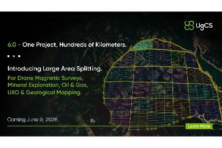
In traditional large-scale magnetic survey operations, professionals must first use third-party software to divide vast survey areas into multiple sub-areas before executing flight missions. This fragmented workflow is complex and time-consuming, often leading to overlap errors and data misalignment. The new "Large Project" feature in UgCS 6.0 allows operators to directly import large polygons and automatically split them into smaller sub-areas while ensuring perfect grid alignment across the entire site. This version also introduces a "Connecting Lines" function, enabling built-in quality assurance/quality control data validation directly within the flight plan to ensure data integrity. Additionally, the "Shift Right" parameter allows pilots to adjust the current flight grid to precisely match historical survey lines, meeting the needs of long-term mining and geological monitoring.
UgCS 6.0 updates the terrain-following algorithm with the launch of Smart AGL 2.0. While the earlier version's AGL altitude mode controlled the drone's safe distance from the ground directly below and ahead, Smart AGL 2.0 additionally checks the safe distance on the drone's sides.
Kristaps Brass, UgCS Product Lead at SPH Engineering, stated that data inconsistencies between multiple flight missions often cause survey teams to spend weeks on post-processing and field rework. UgCS 6.0 standardizes data collection at the source by moving complex geophysical grid planning to the flight execution phase, automatically aligning sub-areas, and adding connecting lines.
UgCS has long served as a foundational flight planning architecture for demanding environments such as open-pit mines, remote oil and gas pipelines, and heavy construction sites. The release of UgCS 6.0 provides tailored solutions for commercial operators while continuing to support top-tier environmental and geological researchers worldwide through the UgCS for Universities program.
This article is compiled by Wedoany. All AI citations must indicate the source as "Wedoany". If there is any infringement or other issues, please notify us promptly, and we will modify or delete it accordingly. Email: news@wedoany.com