
en.Wedoany.com Reported - The New York City Department of Transportation (NYC DOT) is deploying AI-powered street activity sensors at approximately 100 locations across the city's five boroughs, expanding on a pilot program that began at 20 intersections in 2023.
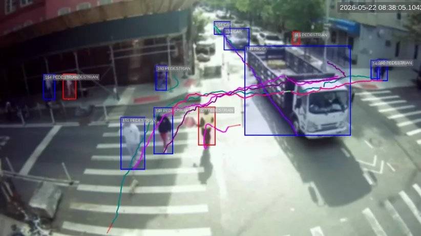
The sensors, provided by Viva (known as VivaCity outside North America), are installed on existing street furniture and anonymously track pedestrians, bicycles, buses, and motor vehicles in real time. Image data is processed on the device and immediately discarded, with only anonymized aggregate data retained; all faces and license plates are obscured.

NYC DOT Commissioner Mike Flynn stated that safer street design begins with understanding actual street conditions, and these sensors will help evaluate the behavior patterns of pedestrians, cyclists, and drivers, thereby designing safer streets and promoting safe behavior.
From pilot to citywide rollout, the initial deployment of 20 sensors replaced traditional manual traffic counts, which relied on short-term, labor-intensive field surveys. The expanded network captures continuous data across diverse corridors—from busy commercial streets to residential areas—reflecting an overall picture of New York City's transportation network.
In addition to counting road users, the sensors measure speed, record turning movements, and map motion trajectories. NYC DOT cites one application case: identifying locations where pedestrians frequently cross mid-block, which can inform decisions on installing new crosswalks.
The sensors also capture data on travel patterns changing over time, seasons, and street layouts, supporting dynamic evaluation of infrastructure projects.
NYC DOT plans to use sensor data for multiple tasks: evaluating the effectiveness of street redesign and safety programs, using near-collision data to identify high-risk locations before accidents occur, improving street space allocation among pedestrians, bicycles, and motor vehicles, supporting access to transit, loading zones, and local businesses, and establishing a longitudinal dataset to track changes in pedestrian and bicycle traffic citywide.
The London-based company stated that its sensors have been deployed by over 260 authorities in North America, the UK, Ireland, continental Europe, Australia, and New Zealand.
This article is compiled by Wedoany. All AI citations must indicate the source as "Wedoany". If there is any infringement or other issues, please notify us promptly, and we will modify or delete it accordingly. Email: news@wedoany.com