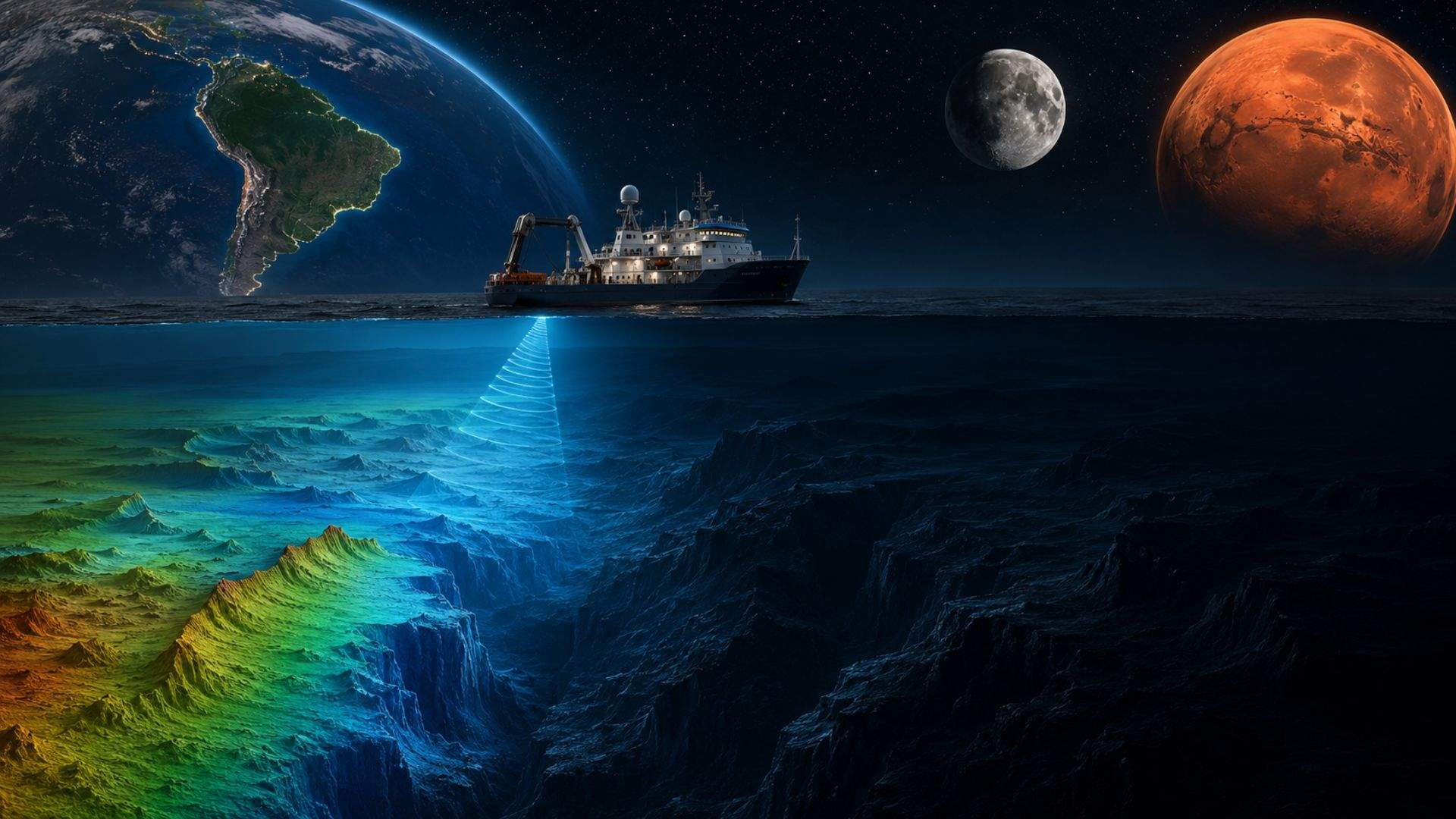
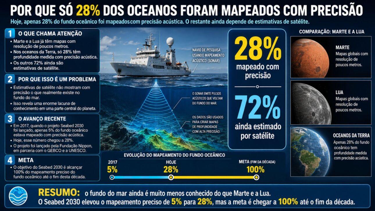
en.Wedoany.com Reported - Currently, only 28% of the ocean floor has been accurately mapped using acoustic methods, a figure lower than our knowledge of the surfaces of Mars and the Moon. The Seabed 2030 project, launched in 2017 by the Nippon Foundation in partnership with GEBCO and UNESCO, has increased the proportion of accurately mapped seabed from 5% to 28%, with the goal of completing the mapping of the entire ocean floor by 2030. The remaining 72% of the ocean floor relies solely on satellite data estimates, which are insufficient to reflect the true conditions of the seabed.
The gaps in ocean mapping have strategic implications for shipping safety, sovereignty, climate models, biodiversity, and resource development. For Brazil, this issue is directly tied to the sovereign scope of the "Blue Amazon" (Amazônia Azul) — Brazil is applying to expand its Exclusive Economic Zone from 3.6 million square kilometers to 5.7 million square kilometers, with 80% of this area having water depths exceeding 200 meters, requiring a deep understanding of the seabed topography.
Ocean mapping technology has undergone a long technological evolution, from the sounding lead to modern multibeam echo sounders. The initial method involved lowering a weighted rope into the sea, which was slow and imprecise. In 1855, Matthew Fontaine Maury produced one of the first charts of the Atlantic Ocean; the Challenger Expedition (Expedição Challenger) from 1872 to 1876 sailed approximately 130,000 kilometers and conducted over 500 soundings, marking the birth of modern oceanography. In the 1970s, Marie Tharp, Bruce Heezen, and Maurice Ewing of Columbia University produced the first detailed map of the ocean floor. Tharp's work, which faced decades of resistance in a male-dominated field due to her gender, ultimately became central to the theory of plate tectonics.
Modern multibeam echo sounders not only measure depth but also use backscatter signals to determine the type of seabed substrate, including rock, silt, sand, algae, or reefs. Combined with topographic data, this information can be used to create maps of marine geodiversity, and artificial intelligence algorithms are being trained to classify seabed types, helping to predict species distribution, fishing grounds, and mineral resources.
Accurate seabed topography is crucial for preventing natural disasters such as tsunamis and for guiding the installation of submarine cables and offshore facilities. Deep-sea corals, hydrothermal vents, and seamounts host unique ecosystems, many of which are not yet fully understood. Over the past 15 years, despite limited resources, Brazilian researchers have described submerged reefs on the Abrolhos Shelf (Plataforma de Abrolhos), submerged rivers off Espírito Santo, and reef structures at the mouth of the Amazon River, revealing vast unknown areas.
The years 2026 and 2027 represent a window of opportunity for ocean mapping in Brazil. The Schmidt Ocean Institute (Instituto Schmidt Ocean) has dispatched the research vessel "Falkor" to the Southwest Atlantic to conduct expeditions in collaboration with Brazilian and international researchers. The vessel is equipped with autonomous underwater vehicles capable of mapping down to 6,000 meters depth and remotely operated vehicles that can dive to 4,500 meters. The ocean economy accounts for approximately 6.4% of Brazil's GDP and 4.5% of its employment. Researchers point out that to seize this opportunity, the nation must treat the ocean as a strategic priority; some corporate data already collected remains confidential, limiting its scientific application.
This article is compiled by Wedoany. All AI citations must indicate the source as "Wedoany". If there is any infringement or other issues, please notify us promptly, and we will modify or delete it accordingly. Email: news@wedoany.com